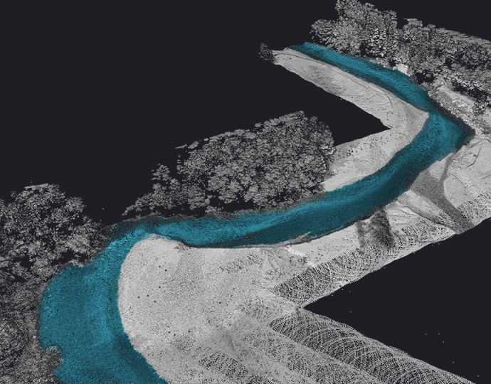
High-precision 3D data capture and processing for accurate modeling, analysis, and visualization of complex environments.
Traditional measurement techniques struggle with complex environments, vegetation penetration, and rapid data capture. LiDAR technology overcomes these limitations with millimeter-accurate 3D data collection regardless of lighting conditions.
Traditional methods can't efficiently capture complex 3D environments
LiDAR captures millions of precise 3D points rapidly and accurately
Capture precise 3D measurements with centimeter to millimeter accuracy.
Collect millions of data points per second from air, vehicle, or tripod.
See through foliage to capture ground topography under vegetation.
Active sensing technology works regardless of lighting conditions.
The YellowScan Bathymetric system is designed for conducting bathymetric measurements in shallow waters and is rapidly deployable on a UAV. This full waveform LiDAR system ensures continuity between underwater points and the surrounding terrain.
Intended for aerial use on drones, the system covers various water areas such as shorelines, rivers, lakes, estuaries, ponds and gravel pits. Navigator is user-friendly and adaptable for a wide range of applications, from hydrographic surveys to underwater resource management.
In complex urban environments, Atlasgeotech advanced classification handles dense clusters of buildings with precision. It efficiently separates individual structures from overlapping elements such as roads, vegetation, and adjacent buildings. The automated process eliminates the need for parameter fine-tuning, ensuring consistent and detailed building identification in intricate urban landscapes.
Atlasgeotech excels at classifying buildings in rural areas, where structures are often sparse and surrounded by natural terrain. The algorithms accurately distinguish buildings from features like vegetation and ground, even in large and uneven landscapes.
Enhancing electrical corridor monitoring with Atlasgeotech to accurately classify wires and transmission towers.
Quickly and accurately classify complex structures like wires and transmission towers without the need for manual adjustments or parameter tuning.
Canopy height models, biomass estimation, and forest inventory with unparalleled accuracy.
Power line corridor mapping, clearance measurements, and infrastructure planning.
3D city models, flood zone mapping, and infrastructure development planning.
Road design, railway corridor mapping, and airport obstruction analysis.
Volume calculations, slope stability analysis, and operational planning.
Watershed delineation, floodplain mapping, and hydraulic modeling.
Parameter | Airborne LiDAR | Mobile LiDAR | Terrestrial LiDAR |
---|---|---|---|
Pulse Rate | 50-2000 kHz | 100-2000 kHz | 10-1200 kHz |
Accuracy | 5-20 cm | 1-5 cm | 1-3 mm |
Point Density | 1-100 pts/m² | 100-5000 pts/m² | 100-10,000 pts/m² |
Range | 100-4000 m | 1-300 m | 0.5-300 m |
Integrated Camera | Yes (RGB/NIR) | Yes (360°) | Yes (HD) |
Output Formats | LAS, LAZ, XYZ | LAS, LAZ, PTS | LAS, E57, PTS |
Best For | Large area mapping | Corridor mapping | Detailed structures |
Our advanced LiDAR processing solutions deliver accurate 3D data for your most demanding applications.